ap1_01_a_radaar_lod
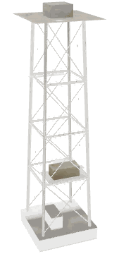
ap1_01_a_radaar_lod is a low-detail (LOD) model of the GTA V map in Los Santos International Airport, from the base game. It measures 23.3 × 23.2 × 62.0 m and is drawn with 458 triangles and 7 textures, up to 500 m away. It is the lower-detail copy of ap1_01_a_radaar that the game draws from far away.
- Model
- ap1_01_a_radaar_lod
- Hash
- 2359747293 (0x8CA6E2DD)
- What it is
- low-detail (LOD) model
- Size (m)
- 23.3 × 23.2 × 62.0
- Size class
- huge
- LOD distance (m)
- 500
- Vertices
- 838
- Triangles
- 458
- Textures
- 7
- Texture dictionary
- ap1_01_a_lod
- Asset type
- drawabledictionary
- Kind
- ydd
- File in the game
- x64l.rpf\levels\gta5\_cityw\airport_01\airport.rpf\ap1_01_a_1_slod1_children.ydd
- Definition file
- airport_metadata_001.ytyp
- Comes from
- the base game (basegame)
- Pack
- basegame
Where it is in GTA V
ap1_01_a_radaar_lod is placed 2 times on the map, most of all in Los Santos International Airport. One of its places: -1275.68, -2447.78, 45.84.
The map files (IPLs) that place it include ap1_01_a and hei_ap1_01_a.
Also placed by ap1_01_a
- 0x02906c65
- 0x076be2bf
- 0x0d705fd8
- 0x126ef557
- 0x29edabd8
- 0x2df8de68
- 0x2eafc394
- 0x37d5eb4f
- 0x3827329f
- 0x3d3d74f2
- 0x3e530669
- 0x490caa8c
local obj = CreateObject(`ap1_01_a_radaar_lod`, coords.x, coords.y, coords.z, false, false, false)